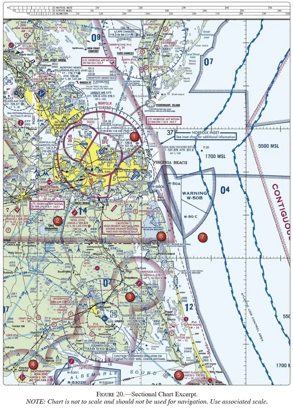
(Refer to Figure 20, area 3.) Determine the approximate latitude and longitude of Currituck County Airport.

Latitude and longitude define position in degrees, minutes, and seconds. Lines of longitude are vertical lines and measure east or west of the 0° (Greenwich) meridian. Lines of latitude are horizontal lines, and measure north or south of the equator. To determine the approximate latitude and longitude of Currituck County Airport, draw a vertical line through the center of the airport symbol parallel to the nearest line of longitude. Then draw a horizontal line through the center of the airport parallel to the nearest line of latitude (or perpendicular to the vertical line you just drew). Note that the lines of latitude at the bottom and top of the page are numbered 36° and 37°. The unnumbered line of latitude in the center of the page therefore is 36°30' North latitude. However, the horizontal line you drew intersects the vertical line of longitude 6 tick-marks below the 36°30' line of latitude, which makes the latitude of Currituck County Airport approximately 36°24'N (each tick-mark is one minute). To measure the longitude, note that the vertical line you drew intersects the 36°30' line of latitude one tick-mark west of the 76° line of longitude, for an approximate longitude of 76°01'W. Answer B is incorrect because this position is well north of Currituck. Answer C is incorrect because this position is off the chart.
(Refer to Figure 21, area 2.) Which airport is located at approximately 47°34'30"N latitude and 100°44'00"W longitude?

(Refer to Figure 21, area 3.) Which airport is located at approximately 47°21'N latitude and 101°01'W longitude?

(Refer to Figure 22, area 3.) Determine the approximate latitude and longitude of Shoshone County Airport.

(Refer to Figure 26, area 2.) What is the approximate latitude and longitude of Cooperstown Airport?

(Refer to Figure 27.) An aircraft departs an airport in the eastern daylight time zone at 0945 EDT for a 2-hour flight to an airport located in the central daylight time zone. The landing should be at what coordinated universal time?

Loading Questions...
(Refer to Figure 27.) An aircraft departs an airport in the central standard time zone at 0930 CST for a 2-hour flight to an airport located in the mountain standard time zone. The landing should be at what time?

(Refer to Figure 27.) An aircraft departs an airport in the central standard time zone at 0845 CST for a 2-hour flight to an airport located in the mountain standard time zone. The landing should be at what coordinated universal time?

(Refer to Figure 27.) An aircraft departs an airport in the mountain standard time zone at 1615 MST for a 2-hour 15-minute flight to an airport located in the Pacific standard time zone. The estimated time of arrival at the destination airport should be

(Refer to Figure 27.) An aircraft departs an airport in the Pacific standard time zone at 1030 PST for a 4-hour flight to an airport located in the central standard time zone. The landing should be at what coordinated universal time?

(Refer to Figure 27.) An aircraft departs an airport in the mountain standard time zone at 1515 MST for a 2-hour 30-minute flight to an airport located in the Pacific standard time zone. What is the estimated time of arrival at the destination airport?

(Refer to Figure 20, area 5.) The CAUTION box denotes what hazard to aircraft?

(Refer to Figure 20, area 2.) The flag symbol at Lake Drummond represents a

(See Figure 52.) Your engine has started to run rough after leaving KLHM (Area 4) in a westbound direction. A landing at Van Dyke Airport

Please see Figure 53. In the airport information box for the MADERA (MAE) airport north of area 2, what does the star next to the letter "L" denote?

(See point 1 in Figure 53.) Near the Grupe (PVT) airport, the highest point on the land is

(See point 4 in Figure 52.) How far south of Lincoln Regional/Harder Airport (LHM) is the only impediment, and how high above the ground is it?

(See point 4 in Figure 52.) How much higher than the airport elevation is the topography at the blockage, which is around 8 NM east southeast of Lincoln Airport?

