FAA Electronic Navigation Exam 1
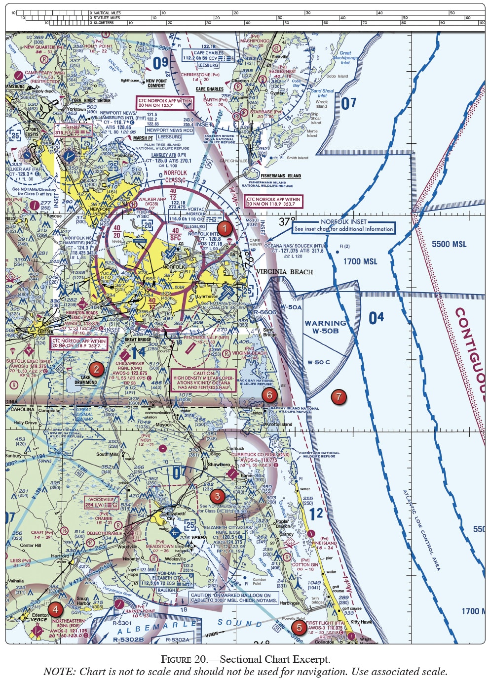
(Refer to Figure 20, area 3; and Figure 28.) The VOR is tuned to Elizabeth City VOR, and the aircraft is positioned over Shawboro. Which VOR indication is correct?
(Refer to Figure 24.) On what course should the VOR receiver (OBS) be set in order to navigate direct from Majors Airport (area 1) to Quitman VORTAC (area 2)?

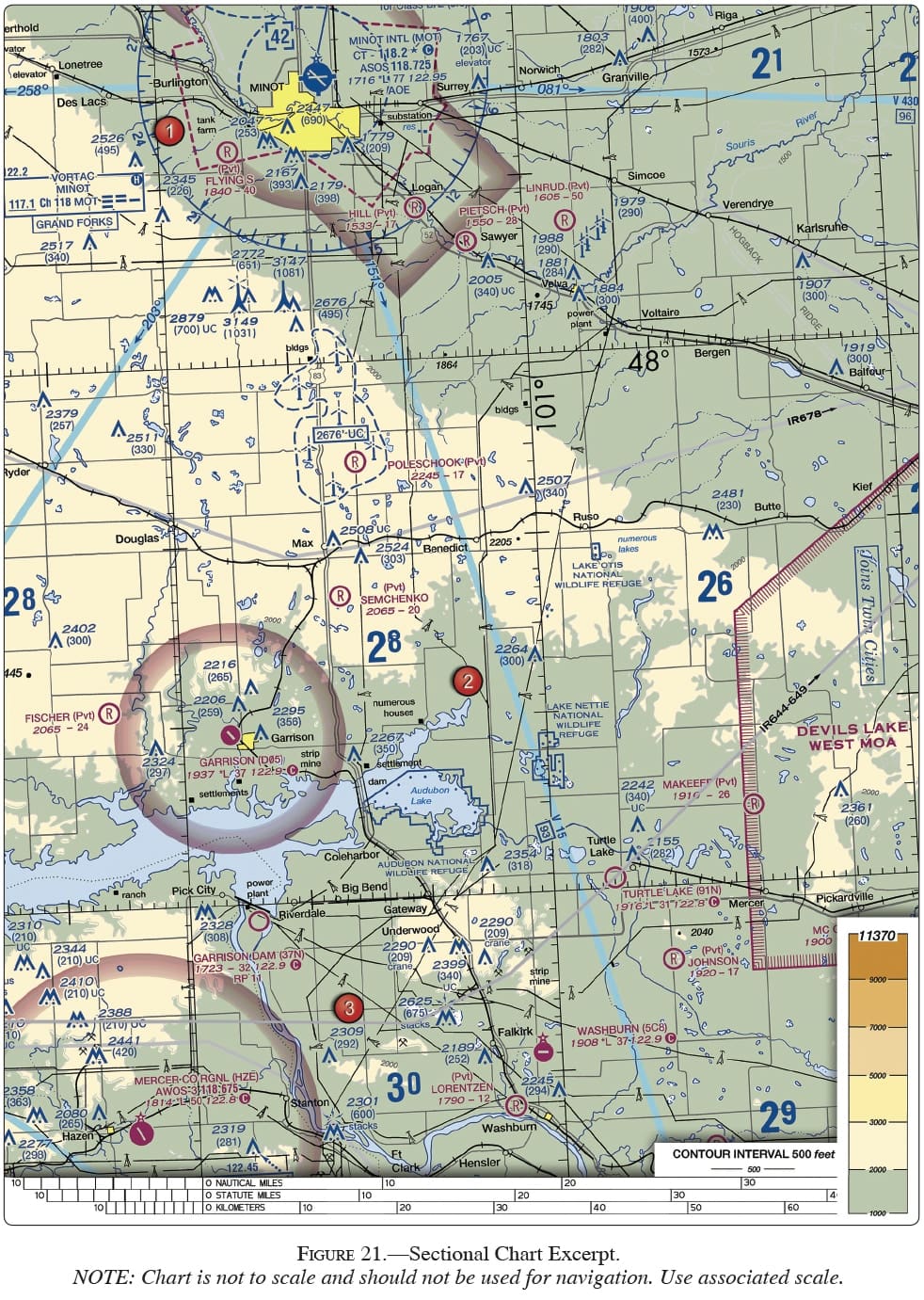
(Refer to Figure 21.) What course should be selected on the omnibearing selector (OBS) to make a direct flight from Mercer County Regional Airport (area 3) to the Minot VORTAC (area 1) with a TO indication?
When the aircraft is at the appropriate checkpoint on the airport's surface, how should the pilot do a VOR receiver check?
Explanation:
The plane can be going in any direction as long as it is at the appropriate checkpoint on the airport's surface. OBS should be placed on the specified radial. The CDI must center with a FROM indication, plus or minus 4° of that radial. The OBS being set to 180° or 000° refers to a check utilizing a VOT, hence answers B and C are incorrect.
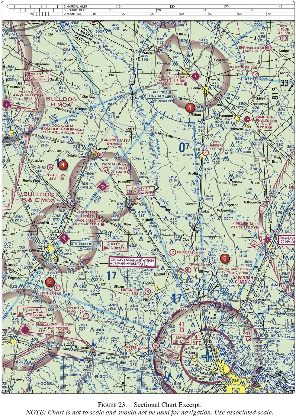
(Refer to Figure 23.) On what course should the VOR receiver (OBS) be set to navigate direct from Hampton Varnville Airport (area 1) to Savannah VORTAC (area 3)?
(Refer to Figure 24.) What is the approximate position of the aircraft if the VOR receivers indicate the 245° radial of Sulphur Springs VOR-DME (area 5) and the 145° radial of Bonham VORTAC (area 3)?

(Refer to Figures 24 and 28.) The VOR is tuned to Bonham VORTAC (area 3), and the aircraft is positioned over the town of Sulphur Springs (area 5). Which VOR indication is correct?
(Refer to Figure 23.) What is the approximate position of the aircraft if the VOR receivers indicate the 320° radial of Savannah VORTAC (area 3) and the 191° radial of Allendale VOR (area 1)?
How accurate does the altimeter need to be when checked before takeoff?
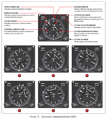
Please see Figure 17. Which statement is true regarding illustration 2, if the present heading is maintained? The airplane will
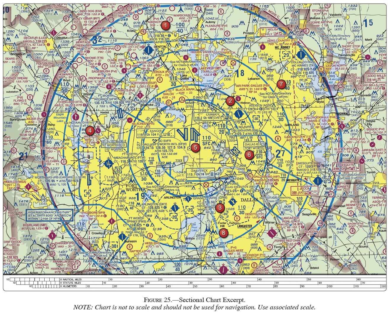
(Refer to Figure 25, area 5.) The VOR is tuned to the Maverick VOR/DME. The omnibearing selector (OBS) is set on 253°, with a TO indication, and a right course deviation indicator (CDI) deflection. What is the aircraft's position from the VORTAC?
(Refer to Figure 28, illustration 7.) The VOR receiver has the indications shown. What is the aircraft's position relative to the station?
(Refer to Figure 20.) What is your approximate position on low altitude airway Victor 1, southwest of Norfolk (area 1), if the VOR receiver indicates you are on the 340° radial of Elizabeth City VOR (area 3)?

Using your plotter, draw a line from the Elizabeth City VOR to extend the 340° radial to where it intersects Victor 1. Using the sectional side of your plotter and reading the nautical miles scale, measure the distance of this point from the Norfolk VORTAC: 18 NM. (Note: Don't get trapped into using the 340 feet MSL obstacle as the 340° radial.). Answers A and C are incorrect because neither distance on Victor 1 would put you on the 340° radial of Elizabeth City VOR.
In the event that the aircraft has a vacuum system for other gyroscopic instruments, what benefit does an electric turn coordinator offer?
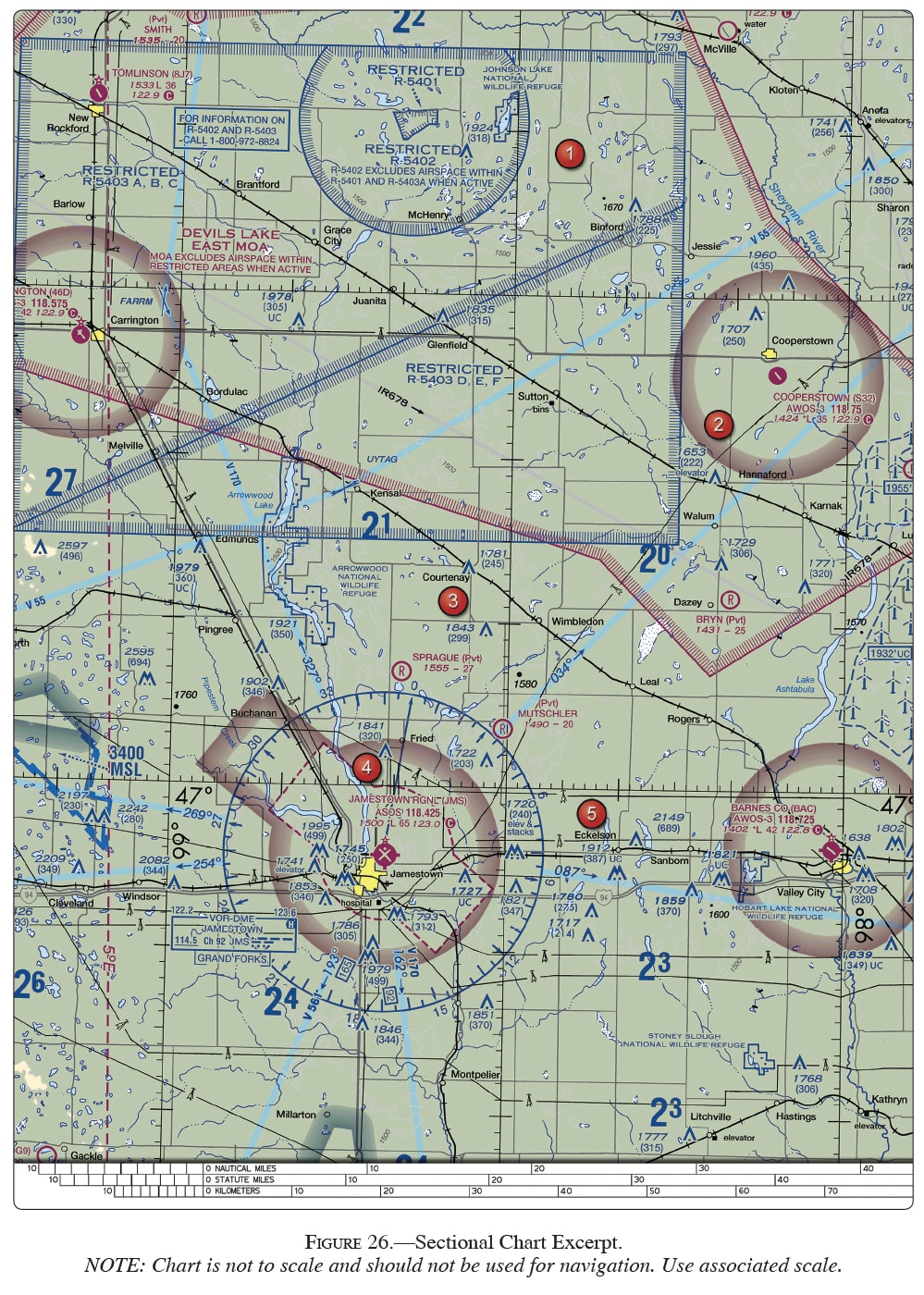
(Refer to Figure 26, areas 4 and 2; and Figure 28.) The VOR is tuned to Jamestown VOR, and the aircraft is positioned over the town of Cooperstown. Which VOR indication is correct?
When using a ground test signal approved by the FAA, what is the maximum bearing error (+ or -) permitted for an operational VOR equipment check?
(Refer to Figure 28, illustration 5.) The VOR receiver has the indications shown. What radial is the aircraft crossing?
