FREE FS Surveying Processes and Methods Questions and Answers
A perpendicular offset is at?
Explanation:
A perpendicular offset is at 90 degrees because a perpendicular line intersects another line at a right angle. In other words, it forms a 90-degree angle with the line it is intersecting.
Which of the following is a term used in traverse surveying?
Explanation:
A theodolite is a term used in traverse surveying. It is a precision instrument that is used to measure angles in both the horizontal and vertical planes. It is commonly used in surveying to determine the direction and elevation of points on the earth's surface. The other options, such as staff, ranging pole, and measuring tape, are also used in surveying, but they are not specifically associated with traverse surveying.
You mark the survey stations using a:
Explanation:
The correct answer is Ranging Pole. Survey stations are marked using a ranging pole, which is a long pole with graduations or markings on it. It is used to establish reference points or benchmarks for measuring distances and elevations during surveying activities. The ranging pole is typically placed at the survey station and serves as a visual reference for the surveyors to take measurements and record data accurately.
Which statement is correct for this road cross-section?
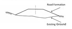
Explanation:
The correct answer is "Fill only section" because the road cross-section is filled with material, indicating that the road is built on top of the existing ground level. There is no indication of any cuts or excavations in the cross-section. Additionally, the statement "the formation level is below NGL" is not applicable to this question and does not provide any relevant information about the road cross-section.
Which of these surveying equipment can be used for linear surveys?
Explanation:
A measuring tape can be used for linear surveys as it allows for accurate measurement of distances in a straight line. It is a flexible and portable tool that can be easily carried and used to measure both short and long distances. The staff, theodolite, and level are not specifically designed for linear surveys. The staff is used for measuring vertical distances, the theodolite is used for measuring angles and horizontal distances, and the level is used for determining the horizontal level of a surface. Therefore, the measuring tape is the most suitable equipment for linear surveys.
What is a global coordinate system?
Explanation:
A global coordinate system, also known as UTM (Universal Transverse Mercator), is a geographic coordinate system that divides the Earth into 60 zones, each with a unique grid system. It is widely used for mapping and navigation purposes, allowing locations to be accurately represented using a combination of easting and northing coordinates. UTM provides a standardized way of referencing locations on a global scale, making it easier to communicate and share geographic data across different systems and applications.
Which statement is correct for this road cross-section?
Explanation:
The correct answer is "Cut only section" because the road cross section shows a slope that has been excavated or cut into the existing ground. There is no indication of any filling or embankment in the section, suggesting that only cutting has been done to create the road. Additionally, the formation level being above NGL is not relevant to determining the correct answer.
Which statement is correct for this road cross-section?
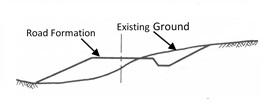
Explanation:
The correct answer is "Cut and fill section." This means that the road cross-section includes both areas where the earth has been cut away and areas where fill material has been added. This is a common technique used in road construction to create a level surface and accommodate changes in elevation. The presence of both cut and fill sections indicates that the road has been built to conform to the natural topography of the area.
You use what type of measurements along the survey line:
Explanation:
The correct answer is "Running" because it is the only measurement type mentioned that is related to speed and movement. Strolling, walking, and trotting are all slower and less intense than running, which suggests that running is the appropriate measurement type for the survey line.
Which of the following is a term used in leveling surveying?
Explanation:
The term "staff" is used in leveling surveying to refer to a long, slender, and graduated rod that is used to measure vertical distances or elevations. It is commonly used in conjunction with a leveling instrument to determine the difference in height between two points. The staff is typically marked with units of measurement, such as meters or feet, and is held vertically at the points being surveyed. By reading the graduations on the staff, the surveyor can determine the difference in elevation between the points.
Which of the following is a term used in linear surveying?
Explanation:
Chainage is a term used in linear surveying to refer to the measurement of distances along a survey line. It is commonly used to mark specific points along a route or track, such as roads, railways, or pipelines. Chainage is typically measured using a chain or tape, and it helps in determining the exact location and distance between different points on a survey line.