FREE FS Surveying Principles and Computations Questions and Answers
What is the height of collimation (HOC) for a Level?
Explanation:
The height of collimation (HOC) for a Level refers to the height of the instrument after it has been set up. This is an important measurement in surveying as it allows for accurate leveling and the determination of elevations. By knowing the HOC, surveyors can calculate the difference in elevation between different points on the ground.
What is the first reading that you take after setting up the level?
Explanation:
After setting up the level, the first reading that is taken is the BS (Back sight) reading. The back sight reading is the measurement taken on a point of known elevation, typically a benchmark, to establish a reference point for the level. This reading helps in determining the height difference between the instrument and the benchmark, which is crucial for accurate leveling.
What is the correct formula to calculate the reduced level (RL) of last point?
Explanation:
The correct formula to calculate the reduced level (RL) of the last point is HOC-FS. HOC stands for height of collimation, which is the height of the line of sight of the instrument. FS represents the foresight, which is the height of the staff at the last point. Subtracting the foresight from the height of collimation gives us the reduced level of the last point.
What does a 1:100 drawing scale mean in surveying?
Explanation:
A 1:100 drawing scale means that 100cm measured in real life will be represented by 1cm on the drawing. This scale is commonly used in surveying to accurately depict large areas or structures on a smaller drawing. By using this scale, surveyors can effectively communicate measurements and dimensions in a more manageable and understandable format.
Where is the best place to set up the level?
Explanation:
The best place to set up the level is where it can target most points if not all. This means that the level should be positioned in a location that allows it to accurately measure and assess the heights or slopes of multiple points on a surface. By doing so, the level can provide a comprehensive and reliable analysis of the terrain or structure being measured.
What is Mean Sea Level (MSL)?
Explanation:
Mean Sea Level (MSL) refers to the average point between high and low tide over a period of time. It is used as a reference point for measuring elevations and depths. MSL is important in various fields such as navigation, surveying, and coastal engineering as it provides a consistent baseline for these activities. By taking into account the fluctuations of tides, MSL helps to establish a standard reference for measuring and comparing sea levels at different locations.
What is the smallest gradations measurement on a staff in ordinary leveling?
Explanation:
The smallest gradations measurement on a staff in ordinary leveling is 0.01m. This means that the staff can be measured in increments of 0.01 meters, allowing for more precise and accurate measurements in the leveling process.
What does a contour line represent?
Explanation:
A contour line represents a group of points with the same elevation. Contour lines are used on topographic maps to show the shape and elevation of the land. Each contour line connects points of equal elevation, allowing us to visualize the changes in elevation across a specific area. By studying contour lines, we can determine the steepness of slopes, identify valleys and ridges, and understand the overall topography of a region.
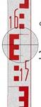
Which reading is the correct reading for the staff illustrated?

Explanation:
The correct reading for the staff illustrated is 1.50m.
What is a Benchmark (BM)?
Explanation:
A benchmark (BM) is a point of known elevation. It is a reference point used in surveying and construction to establish vertical measurements. By knowing the elevation of a benchmark, surveyors can accurately determine the elevation of other points in the area. This helps in ensuring that structures are built at the correct height and that accurate measurements are taken for various purposes.
Which reading is the correct reading for the staff illustrated?
Explanation:
The correct reading for the staff illustrated is 1.58m.